|
There are two things absolutely true about alpine grazing and bushfires:
- The whole story isn’t obvious.
- You can ‘prove’ anything you like with a few photos, particularly when the 2003 fire burnt approx. 1.5 million ha of national park and state forest.
The following points are based on good research, as well as local experience.
How cows affect bushfires
There are three main ways alpine cattle grazing affects fire.
- Cattle promote the growth of alpine shrubs, many of which have a very high oil content in their leaves. These shrubs are the main agent for spreading fire across the high plains. The evidence for this is very well established.
See Maisie’s Remarkable Plot
|
|
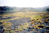 |
Burnt patches caused by exploding shrubs as fire leapfrogged a grassy plain (2003)
|
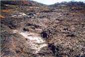 |
Most peat beds in cattle grazing areas were burnt in 2003
|
- Cattle prefer the fleshy herbs (wildflowers) that once covered most of the high plains. Grazing has greatly reduced the extent of these plants, and this has also helped the spread of fire through the high country.
See Maisie’s Remarkable Plot
- Cows eat down grassy areas, slowing the path of fire. This is particularly true of heavily grazed areas (eg farms, and some river flats in the bush), and where tall weedy grasses have grown. But this can only slow the rate of fire in a few areas, and embers from fire in the alps are capable of taking the fire kilometres past such areas.
For grazing by mammals to have a significant fire-reduction effect over eastern Victorian bushland, you would need to employ much more intensive grazers than cattle.
Is there evidence that cattle reduce alpine fires?
No, there isn’t. In fact the progress of three fires is worth looking at.
1939: intensive alpine grazing didn’t stop Black Friday
In the great fire of 1939, when grazing was far more intense than it is today, fire raged out of control right through the alps (indeed the Royal Commission into the 1939 fire held the cattlemen, and their burning-off practices, partly responsible)
1997: all licences in path of fire 100% burnt
In the 1997 Caledonia fire (in the southern section of the park) the fire burnt through national park ungrazed areas, national park grazed areas and state forest more-or-less equally. Indeed the fire intensity mapping (available from Parks Victoria) shows no correlation between grazed areas and fire resistance. Not one grazing licence area in the path of the fire remained unburnt.
See Caledonia fire map
2003: most grazing licences 100%burnt
In the fire of 2003, around 1.5 million hectares of north-eastern Victoria went up in flames. Less than half of this was in the Alpine National Park, and about half was in State Forest. There were active grazing licences throughout the area, both in state forest and national park.
Most of the licences within the path of the fire were 100% burnt. (20 National park grazing licences were 100% burnt, 13 were over 95% burnt, and the average was 94%, based on aerial mapping.)
And we can learn more…
Fire mapping for the 2003 fires is more comprehensive and more detailed than any fire in Victoria’s history, and it will take some time to assimilate all the data. When this is done, however, we should be in a position to make an even better assessment of the affects (if any) grazing has on the spread of fire.
|